The Best Places to Take Photos in Oregon
Unveiling Oregon's Hidden Gems: A Photographer's Guide to its Top 10 Picture-Perfect Spots
Oregon is not short on dramatic views. Oregon landscape photography is some of the most moving you’ll find because the state is positively packed with epic natural beauty. From the towering Cascade Mountain Range to the depths of the Umpqua National Forest, the plunging Columbia River Gorge, and the churning Pacific Ocean, Oregon is breathtaking.
Explorest’s archive of Oregon photography will take you behind the scenes of some of these awe-inspiring shots. Download our travel app to check out beautiful photography of Oregon and tips for how you can snap your own shots, too. Our creators share their favorite locations to take photos around Oregon and give you step-by-step guidance on how you can create perfectly crafted compositions. You can check out their work on Explorest, and you may even feel inclined to buy one of the images to display as your own NFT art.
Oregon’s landscape is shrouded in mystery. It’s full of secret coves, hidden plunge pools, the highest peaks, and the most serene lakes. If you’re ready to discover the very best of Oregon landscape photography, here are the best Oregon photography locations.
Face Rock State Scenic Viewpoint
Rising dramatically off the Oregon coast, Face Rock looms out of the water with an ethereal, haunting beauty. A walk along the sand of this unique beach reveals a row of humongous sea stack rocks that rise out of the sea like piercing shards of glass. Tip: The best time to visit the viewpoint is in winter when you'll find the waves are far more dramatic. Explorest photographer Andrew Studer recommends shooting at sunrise or sunset for a velvety purple sky.
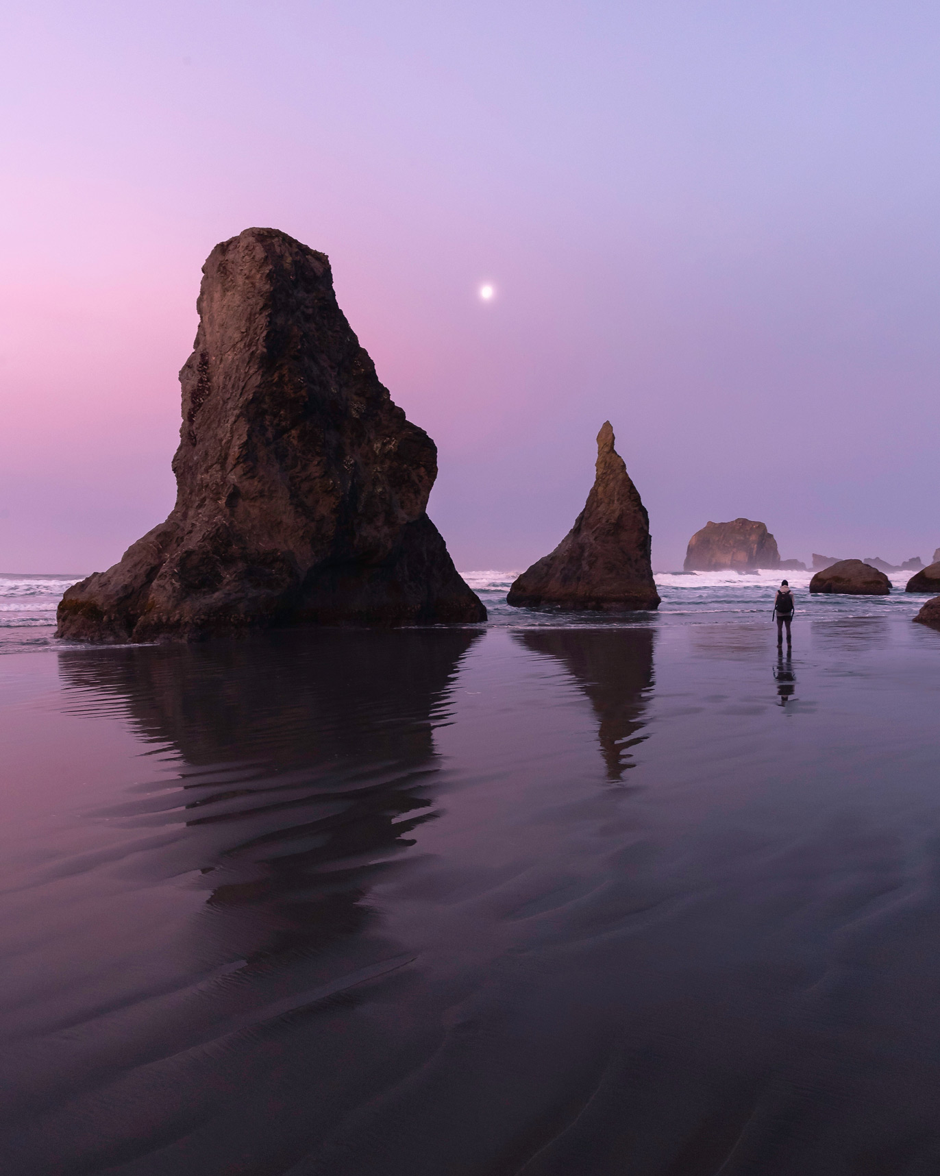
credit: @andrew.studer — discover Face Rock State Scenic Viewpoint on the Explorest app
Sunset Beach and Sunset Bay
One of the most scenic corners of the Oregon coast, Sunset Beach has a little something for everyone. From carpets of wildflowers and thick, virgin forests, to sweeping views of the Pacific Ocean, it's no wonder this is one of the top photography spots in Oregon. The best views are within Sunset Bay State Park near Coos Bay. It's marked by sandy beaches, towering sea cliffs, and a web of hiking trails that connect the bay with other nearby parks. Explorest photographer Romain Farge likes shooting along the beach at sunset for the most dramatic, golden-hued shots.
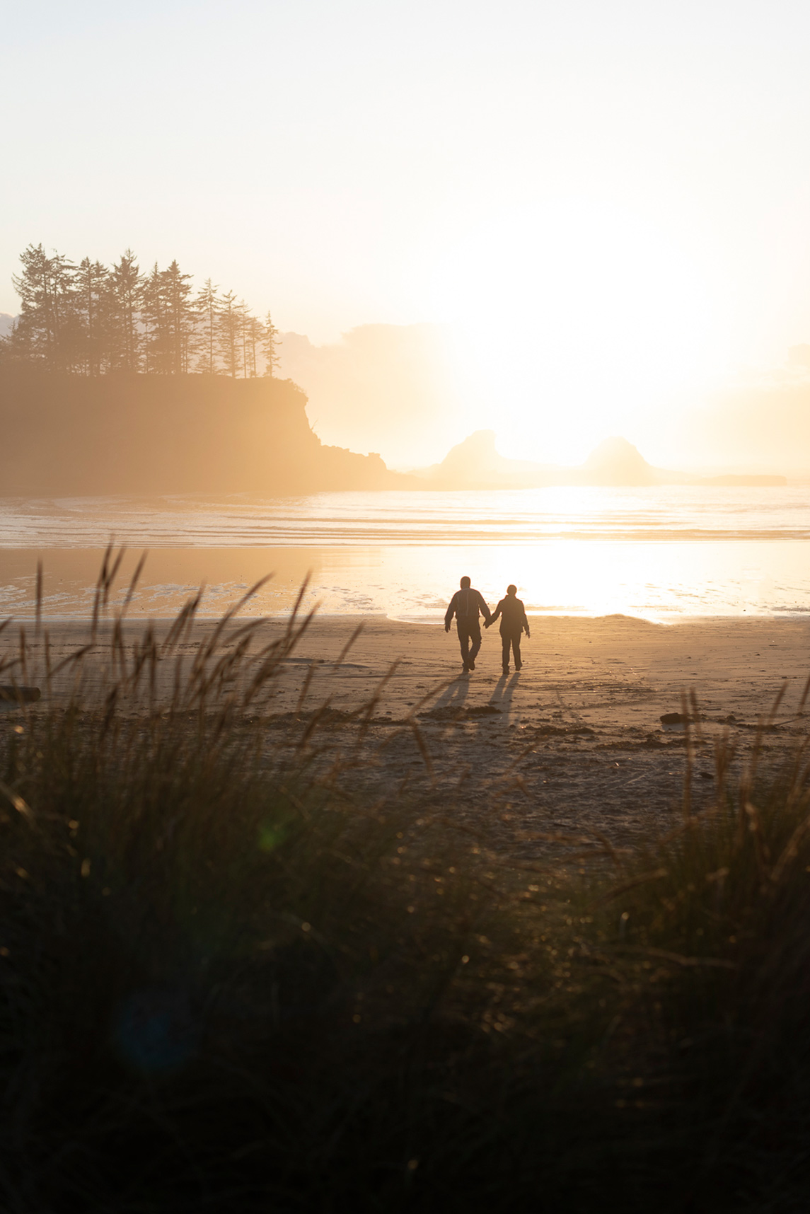
credit: @ledoigtdansloeilfr — discover Sunset Beach and Sunset Bay on the Explorest app
Broken Top Mountain from Sparks Lake
Of all the peaks in Oregon—and there are many—none hits quite like Broken Top. Broken Top is a complex stratovolcano out of the Cascade Range, nestled within the heart of the Three Sisters Wilderness. Though the volcano has been dormant for about 100,000 years, its sheer beauty and mystery remain. If you want the best shot of Broken Top, head to Sparks Lake, located in the Deschutes National Forest. Arrive before sunrise to capture the cotton candy colors and the serene reflection of Broken Top on the glassy surface of the water.
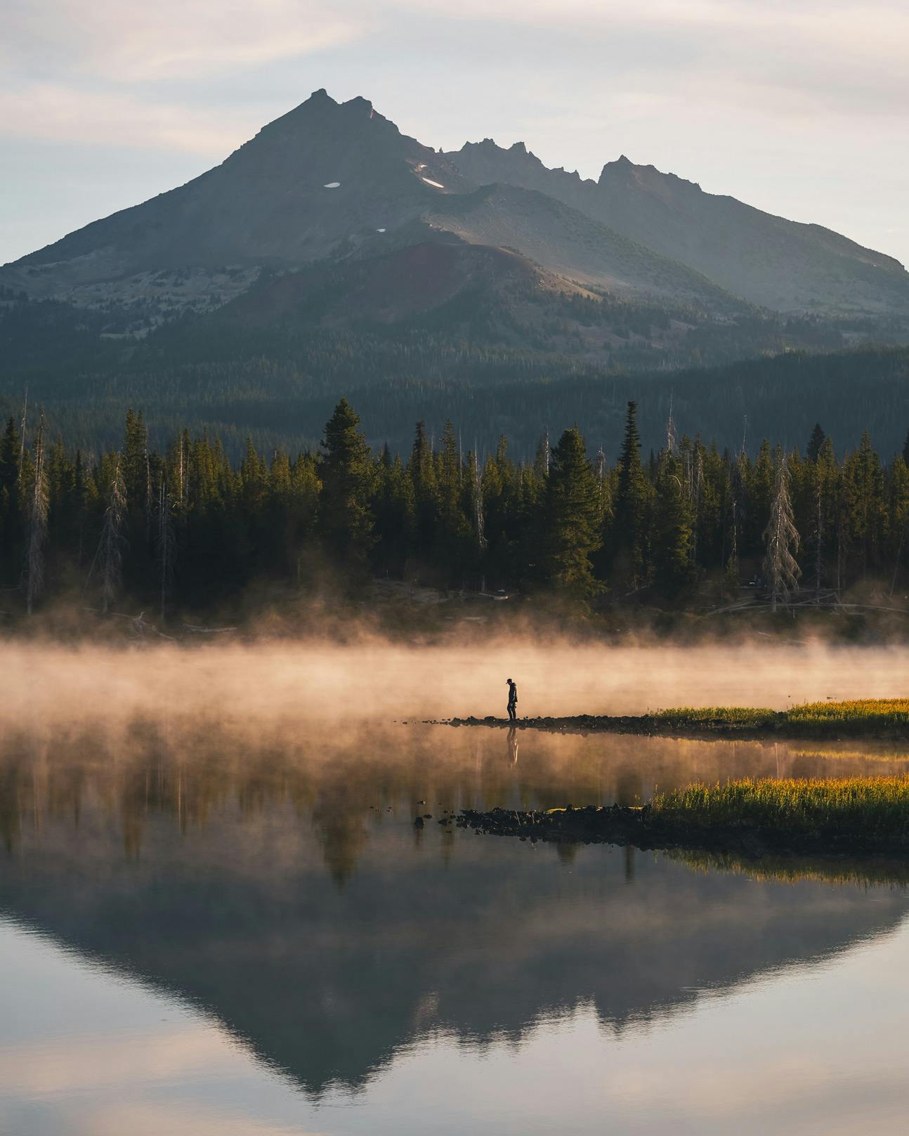
credit: @scott_kranz — discover Broken Top Mountain from Sparks Lake on the Explorest app
Wahclella Falls
Oregon is not short on waterfalls, but if you want to shoot one of the best waterfalls in the state, you'll want to head to Wahclella Falls. The journey to the falls is as exciting as the destination. Follow a relatively easy, 2.4-mile out-and-back hike through a slot canyon to reach the epic falls. The best angle, according to Explorest photographer Michael Matti, is just off the Wahclella Falls Trail, with a view of the falls and the Upper Tanner Creek Bridge. Find the rock field to the right and climb atop one of the rocks for the best vantage point to shoot the gushing plumes of water as they cascade down the rock face.
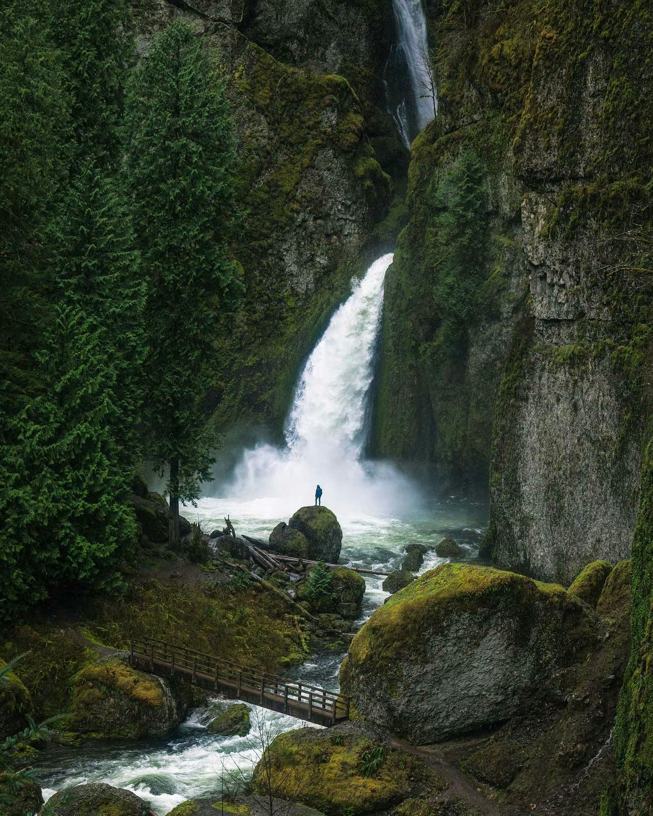
credit: @michelmatti — discover Wahclella Falls on the Explorest app
Secret Beach
Oregon has more than 360 miles of coastline, so you can imagine that it isn't short on beaches. But perhaps one of the most beautiful beaches in Oregon is Secret Beach. Known for its garden of sea stacks that rise above the waterline, there is something untamed and wild about this spectacular beach. What keeps the beach a secret is the relatively steep trail that separates it from the highway. You'll find the trailhead just south of milepost 345 along the US 101. Explorest photographer Jesse Roos says to bear right to the side trail that takes you to the top of one of the sea stacks. From there, you'll have the perfect setup to capture the secrets of Secret Beach.
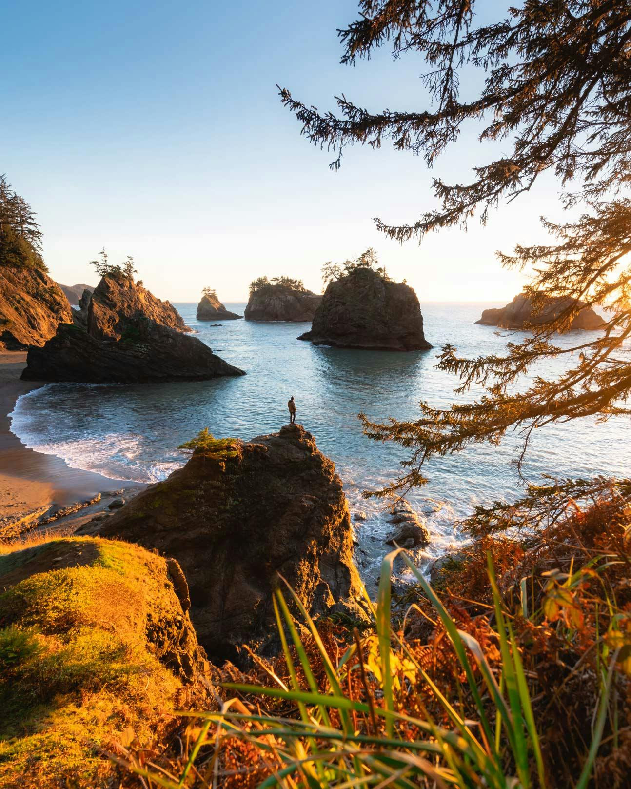
credit: @jesseroos — discover Secret Beach on the Explorest app
Mount Jefferson from Triangulation Peak
Behold the second-highest peak in the state of Oregon. Mount Jefferson rises above the Cascade Range at a staggering 10,500 feet above sea level. The snow-capped stratovolcano is known for its remote and rugged beauty and happens to be one of the most difficult volcanoes to access in the Cascades. That said, you can grab a perfect shot of the peak from Triangulation Peak. In fact, if you summit Triangulation Peak, you'll feel like you're standing right next to Mount Jefferson. It's a steep climb to the top but once you reach the summit plateau, you'll have spectacularly sweeping views across the Cascades.
credit: @jesseroos — discover Mount Jefferson from Triangulation Peak on the Explorest app
Toketee Falls
The wild forests of Oregon are teeming with jewel-like pools of water fed by gushing waterfalls. One of the best waterfalls in Oregon is none other than Toketee Falls, tucked within the Umpqua National Forest. The falls seem to spring from the pages of a fantasy novel. A dramatic cascade of white rapids careens down jungle-carpeted volcanic rock, splashing into a deep turquoise pool 113 feet below. You can snap gorgeous pictures from above the falls. Or, if you are a particularly experienced hiker or climber, you can scale your way down to the bottom of the falls for a truly epic shot. But be warned that this is an extremely treacherous scramble, so only experienced hikers should attempt it.
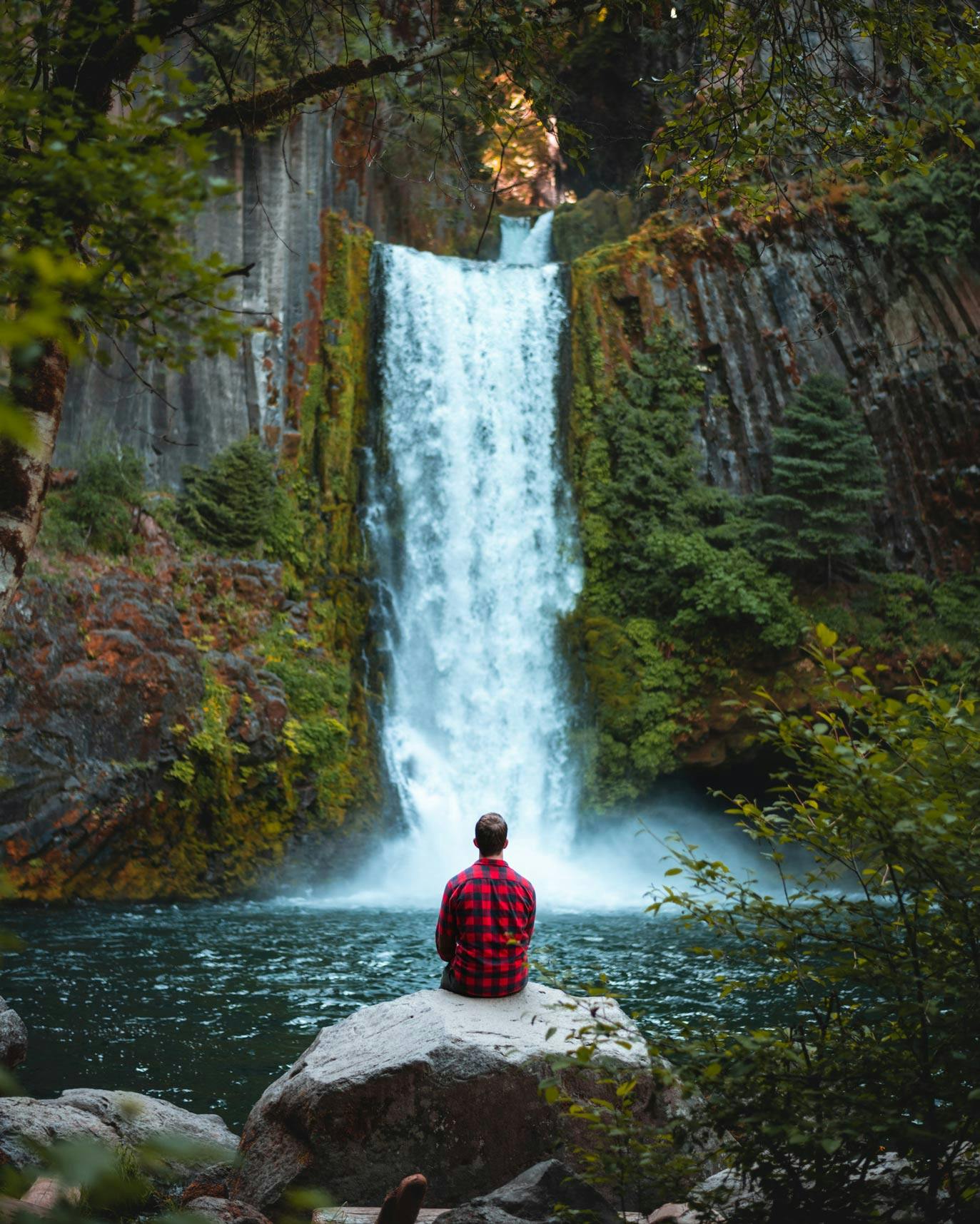
credit: @zachnicholz — discover Toketee Falls on the Explorest app
Imnaha River from Cow Creek Trail
Coursing its way through the Wallowa-Whitman National Forest, the Imnaha River is a 77-mile waterway that runs through the thick of Oregon's wilderness. The river starts in the Eagle Cap Wilderness before emptying into the Snake River. It's one of the most naturally beautiful landmarks in Oregon, particularly if you catch a glimpse of it from Cow Creek Trail. Surrounded by canyon walls, you'll have impressive river views and magical compositions all throughout the hike. Explorest creator Chad Torkelsen says the best shot is about three miles down the trail where the landscape opens up to reveal the river winding its way at the base of a sloping valley wall topped with rocky peaks.
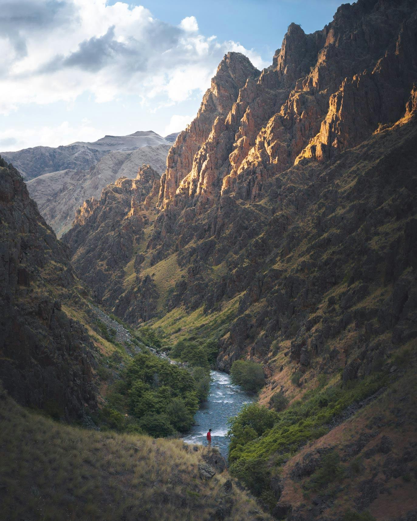
credit: @chadtorkelsen — discover Imnaha River from Cow Creek Trail on the Explorest app
Cannon Beach and Haystack Rock
Anyone who has ever seen The Goonies has Cannon Beach and Haystack Rock on their Oregon bucket list. And for good reason—it’s a beautiful spot and one that makes for fantastic photos. The iconic rock formation towers 235 feet above a shimmering shoreline. The thin layer of water on the sand below acts like a reflecting pool that adds so much beauty and drama to a shot. For the best shots of Haystack Rock, head to the northern side of the rock on the beach and face southwest. If you go at sunset, the colors of the sky behind the rock will be simply incendiary.
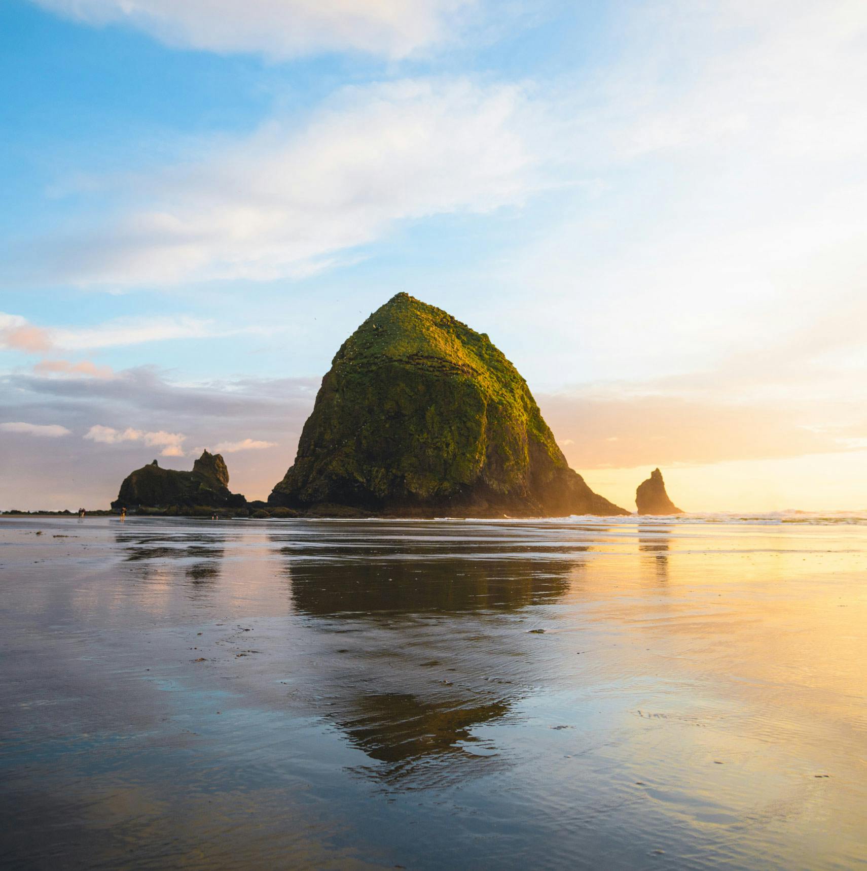
credit: @zachnicholz — discover Canon Beach and Haystack Rock on the Explorest app
Elk Flats
There are far fewer dramatic views along the coast of Oregon than on Elk Flats. About 20 minutes south of Cannon Beach, this craggy coastal shot has panoramic views of the churning Pacific and the evergreen-capped cliffs that stretch out into the distance. From the highway pull-off along the 101, it is about a quarter-mile hike to reach the clifftop perch. The best way to photograph this spot, according to our creator Chad Torkelsen, is to use a drone. Be sure to check local drone regulations before you fly yours. If you're going without a drone, you can still get some excellent photos from the viewpoint of the cliffs and the ocean.
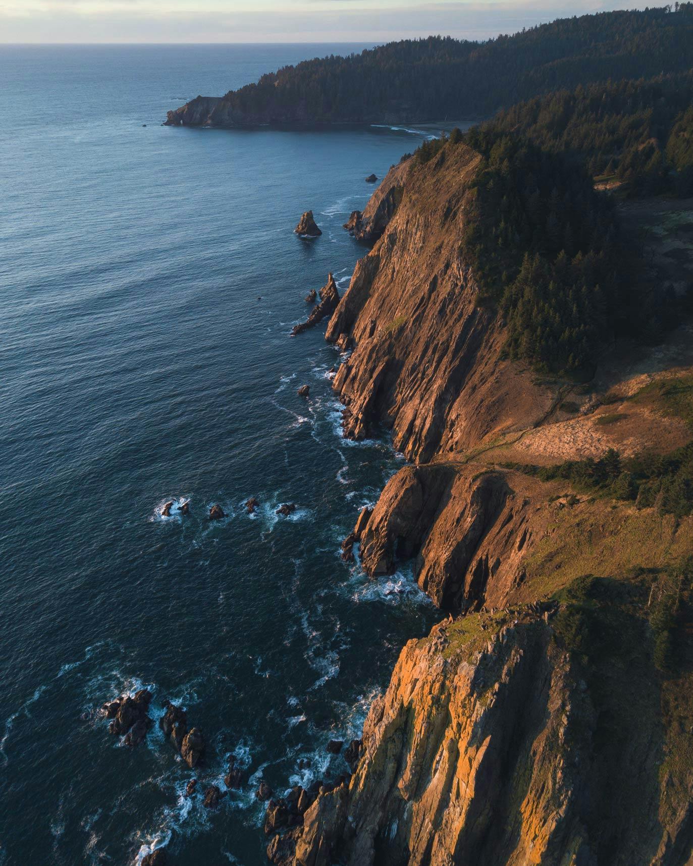
credit: @chadtorkelsen — discover Elk Flats on the Explorest app
If you want to discover new photo spots, download the Explorest travel app today. We provide insider recommendations to help you photograph your travels, near and far.